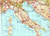
Cartographic viewer of Spain
Imagen
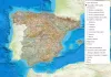
Body
Mapping used:
Mapping used:
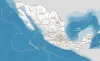
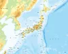
Cartographic viewer with Mexican spatial data infrastructure services, offered by the public body in charge of its publication. It allows you to explore different styles of topographic maps, aerial orthophotos and the hypsographic map of Mexico.
Mapping used:
Source and download of official data:
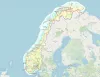
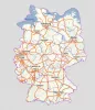
Mapping viewer with Norwegian spatial data infrastructure services, provided by the Norwegian Land Registry and Land Registry Authority. It allows you to explore and access information on topographic, historical maps, roads, aerial orthophotos, MDT, MDS or the administrative limits of Norway.
Mapping used:
Source and download of official data:
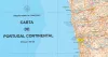
Official geoinformation pages of the Government Portuges:
Portal iGEO Geographic Information
Dire-o-Geral do Território (DGT)
Cartography used:
Published mapping:
Data sources:
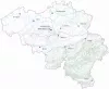
- Topographic maps of Belgium offered by the Institut Géographique National (IGN) at different scales (1:250,000, 1:100,000, 1:50,000, 1;25,000). The maps show all the topics of the Topogeographic Inventory of the Belgian Territory (ITGI) prepared and updated by the National Geographic Institute: land use, transport, hydrography, buildings. and constructions, reliefs, cartographic labeling and place names.
Mapping used:
For more information and to download cartography:
http://portaleslr.carm.es/web/sitmurcia
With the photo comparison tool you can view two aerial images of the same specific geographic area at the same time. Flights are performed without a chronological or spatial order, so you can find places where there is no photographines in a particular year. WMS services offered by various state and regional institutions have been used to achieve the interactive map. Here are some examples where you can observe changes in localized spaces over time.