Cartographic viewer of Spain
Imagen
Body
Mapping used:
Mapping used:
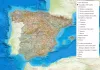
The Camino de Santiago is a historic pilgrimage route that starts from different places and reaches Santiago de Compostela, where the tomb of the Apostle is located. The map offers the complete route of all the Jacobean routes at European, Spanish and UNESCO-declared level.
The routes offered are the official ones made by the IGN from different collaborationsadores, with the information of the stages:
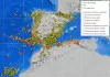
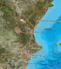
Cartography and data with seismic and volcanic information from Spain. The added layers provide parameters of seismic hazard, seismic stations, volcanic watch stations and the IGN earthquake catalog.
Earthquakes cataloged in the IGN with day and time information, depth, magnitude, location and intensity:
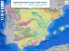
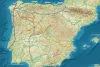
Consult all the geological mapping of Spain elaborated by the IGME in the same viewer and be able to obtain geoscientific information of different geological aspects. These include:
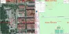
Historical Catastro is the tool that allows you to compare cadastral mapping on different dates to visualize the modifications that occurred. Historical mapping is only available from the time you have cartography in digital format (not before 2002) to the current date.
For more information and downloads:
http://www.catastro.meh.es/
For more information and download of cartography of the Valencian Community:
http://www.icv.gva.es
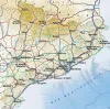
More information and cartographic files to download at:
http://www.icgc.cat/
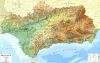
For more information:
http://www.ideandalucia.es/portal/web/ideandalucia/
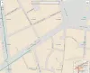
Interactive map with all the cartography concerning the cities and towns of Spain. In it we can locate the administrative divisions, the municipal terms, the names of the streets, the numbering of the portals, the kilometer points, the census districts and other information of urban cartography.
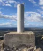
The geodesic vertex viewer allows us to locate where the monoliths, built along the peninsula, are located, using the topographic maps, Opeen Street Map and the current aerial orthophoto. It also includes the reviews provided by ign, with situation mapping, coordinates, milestone data, in pdf format when clicking on them.